Thursday, January 31, 2008

2008 1/31 The Queen Charlotte Track


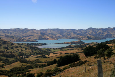
We decided to take the water taxi across the sound for another wonderful walk. The head of the Queen Charlotte II Track was located about 500 meters off the main road. The track started with a fairly steep climb to the the highest point on the track where we enjoyed gorgeous 360 degree views of the Kenepuru Sound. We continued walking 3 1/2 hours, meeting fellow trampers and mountain bikers along the way. There were at least two more good climbs involved, then it was down hill for the remainder, all the time winding through scenic reserves, private land and DOC maintained park lands. We ended at the backpacker store for a sandwich and a cold drink, bumping into our water taxi driver - what timing! He was there picking up another couple who were just checking into Raetihi. In no time we were freshly showered, feet perched into the air on soft pillows, settling back into our book - marked just where we left it.

Wednesday, January 30, 2008

2008 1/30 Track to the Scenic Reserve


When we arrived Raetihi Lodge we settled into our rooms and immediately began looking at our walk options. We decided to head away from the lodge to the scenic reserve, about an hour's walk to the West. It was a nice track, very flat with few rocks and tree roots to manouver through. We enjoyed a cool day as cloud cover protected us from the sun. The fragrance of the clean air and the beauty of the native bush was very relaxing and we enjoyed it very much.

When we returned from our walk, we settled in with a nice glass of wine and watched the light dim across the water from our balcony.

Tuesday, January 29, 2008

Kenepuru Sound, Marlborough


We arrived Raetihi Lodge in the Kenepuru Sound, Marlborough. Kenepuru Sound is the third largest of the four Sounds that make up the Marlborough Sounds at the top of the South Island, New Zealand. The others are the Queen Charlotte, Pelorus and Mahau Sounds.

The Sounds are a series of drowned valleys formed millions of years ago. There are islands, big bays, tiny inlets, narrow points of land, steep hill sides, and some flat areas. Mt. Stokes is the highest peak at 3,948 feet and is the only subalpine area within the Sounds. The area consists of approximately 1,200 kilometeres of coastline within an area covering of approximately 1,000 square meters.

The scenery differs vastly from each area. High outcrops and cliffs, steep windswept hillsides in the outer sounds, or as you progress into the Sounds the hills have been cleared for farming, although some are still covered in native bush. Pine plantations cover large areas, mostly on previously farmed land. Houses are perched on hillsides or are tucked away into little bays.

Kenepuru is famous for snapper fishing, boating and you will also see many marine farms along the coastline for the farming of green lipped mussels found only in New Zealand.

Monday, January 28, 2008

2008 1/29 We're Back!

It's been almost 2 weeks since we've had access to the internet for any length of time. We've put quite a few photos on Flickr so feel free to take a look. When time allows, Nancy will put a few details of our travels on this blog. Hope all is well with everyone. Cheers!

2008 1/28 Final Day at Abel Tasman


We begin Day 3 of our tour of Abel Tasman as we walk from Awaroa Bay where we will meet the water taxi at Totaranui. After the long walk yesterday, we are glad today is only 2 hours of walking. It's been a great way to see the park. Every turn along the coast offers up a beautiful beach, with stunning views. Our walking guide Connie, a nice young lady from Germany, has been sharing stories of her adventures in the Himalayas, which has us thinking about a trip to India. She is in the process of organizing a 19 day trek through the mountains - primitive style - very interesting.

Sunday, January 27, 2008

2008 1/27 Walking Abel Tasman -


Today we begin day 2 of our guided tour as we join the walking group. We will follow the track from Torrent Bay for a full-day walk, ending at Awaroa Bay to have dinner and spend the evening at the Meadowbank Homestead Lodge.

Saturday, January 26, 2008

2008 1/26 Sea Kayaking in the Tasman Sea


We are part of an organized tour that will spend the next 3 days kayaking and walking the Abel Tasman National Park.

Today was our first attempt at sea kayaking and it was very interesting. Our journey started at Motueka where we launched our kayaks and followed the coastline, ending at Torrent Bay. We were on the water about 4 1/2 hours and were ready to be on dry land when the day had come to an end. We managed to stay dry and not capsize our kayak, but waves sure seem much larger at eye level than they appear from a boat.

We enjoyed a nice dinner with our fellow kayakers and the walking group, then it was time for lights out.

We plan to join the walking group tomorrow, as kayaking is not really our thing. We're glad we tried it, but if Nancy's gonna be in the ocean, she needs a bigger boat!


Thursday, January 24, 2008

2008 1/24 NZ, Split Rock Formation; Tonga, Bark Bay, Torrent Bay and Anchorage Bay


This photo was taken from the water taxi while making our way to Tonga. Nancy walked the track from Tonga to Bark Bay with Joe - who then continued to walk further south to Torrent /Anchorage Bay to catch the taxi back to Marahau.

This granite boulder at one time was in one piece, but as you can see it is almost perfectly split down the middle - quite an interesting geological formation.

Wednesday, January 23, 2008

2008 1/23, 24 and 25 NZ, Marahau


Wow - what a difference a couple hundred kilometeres make!

The storm passed and the weather is spectacular. The Northern end of the South Island is spectacular. Bay after bay of gorgeous beach and fantastic walking tracks.

Our cottage is located just outside Abel Tasman National Park. You can reach the track from the beach, or take a water taxi further up the coast and walk back to Marahau. The walks were lovely and we really enjoyed this place. We have a sea kayaking adventure coming up next week where we get to see this area from the ocean - should be a lot of fun.

Tuesday, January 22, 2008

2008 1/21 NZ, Nelson Lakes


The kind DOC Agent let us know the weather forecast for Nelson Lakes wasn't very promising for the next few days, so we immediately headed to the park and hit the trail. We enjoyed a very nice walk through the Beech Tree forest beside the lake.

We were glad we did as we were held-up in our room for the next 2 days due to stormy weather. We were getting the remnants of Typhoon Funa, which lost strength and was downgraded to a tropical storm, which brought steady torrents of rain to the area.


We took the opportunity to catch up on laundry, and read a a bit. Since there were no other towns nearby we had to make due with the one cafe and convenience store in town for our food. The only activities were hiking or boating - since those were not an option - we watched chose between our books and the 2 stations broadcasting on the TV.

2008 1/21 NZ, Hanmer Springs Mountain View from Albergo Lodge


Monday, January 21, 2008

2008 1/18, 19, 20 NZ, Hanmer Springs

Views of the mountain range surrounding Hanmer Springs (located near the center of the
South Island). This shot was taken from near the top of one mountain we were on as we peered through the trees.


Waterfall also near the top of the mountain during our walk.


Wednesday, January 16, 2008

2008 1/16, 17 NZ, Kaikoura


We hiked a local track in Kaikoura yesterday. Nancy managed to get a good sunburn while we were at it. When we began the sky was heavily overcast - as soon as we were too far away from the car park to turn back, the sky cleared and intense sunshine persisted throughout the day. Part of our walk included heading down to the shore. As luck would have it, we were forced to climb up the side of a hill/cliff to get back onto the trail since a couple of very big sea lions decided to sun themselves on the rock and blocked our path. This was quite an experience and Nancy was completely out of her comfort zone. Once we started up there was no turning back and she was practically in tears as she crawled on her belly to the top of the ridge. There was no way Joe could help her either - she was on her own. The climb didn't look that bad from the rocky beach......but we won't be doing that again! Joe, of course, had no problem but he doesn't really want to do that one again either. Grass can be quite slippery when you're going straight up.

Sunday, January 13, 2008

2008 1/13 Christchurch Town Square and Botanical Gardens

We first visited Christcurch in October - we are finding the city to be just a beautiful in January as it was then.

Here are a few pictures of the Botanical Gardens, the Trolley and the downtown square.

Saturday, January 12, 2008

2008 1/12 Driving to Akaroa


The Banks Peninsula is home to numerous bays with lovely little towns. Akaroa is one particularly lovely place. It is located about an hour's drive from Christchurch and the scenery is spectacular.

Thursday, January 10, 2008

2008 1/10 Pororari River Hike and Kayak Trip

This is our final day at Punakaiki so we decided to hike the Pororari River Track. The spectacular limestone gorge has two main features, the river with huge rocks in deep pools and of course the beautiful forest and limestone cliffs!

After finishing our hike and a quick stop for lunch we decided to try our hand at kayaking. It is a lot of fun and your arms get quite a workout - especially when going against the current!

After 2 hours we were ready to head back to our cottage for a lite supper and a good book.

Tomorrow we're off to Christchurch.


Wednesday, January 9, 2008

2008 1/09 Punakaki - Blowhole at the Pancake Rocks

The big attraction at Punakaki are the Pancake Rocks - Limestone carved by the ocean and goodness knows what else has incredible blow holes that spray sea water, especially at high tide. The rocks are beautifully carved by the wind and surf and the waves crashing down on them are quite loud. The walk is well attended and quite a tourist draw.


Tuesday, January 8, 2008

2008 1/08 Hokitika Gorge

We waited patiently for the rain cease and clouds to clear. Finally, we were off to investigate Hokitika.

Hokitika is on the West Coast of New Zealand - so the weather can change in a matter of minutes. Clear one minute, rain the next. This is after all the rainforest - and the area has the most wonderful moss and fern - it is just spectacular.

After driving through kilometers of beautiful dairy farms, we made our way to the Hokitika Gorge. The water is a lovely turquoise from the rock sediment churning in the water after being washed down from the mountains.

During our return to Rimu Lodge we encountered a heard of dairy cows that had escaped their grazing pens. They blocked the road and we slowly edged the rent car through them hoping they wouldn't crush the sides like a tin can. Within a few minutes the dear farmer's wife came to our rescue on her 4 wheeler to part the sea of cattle so we could be on our way!


Monday, January 7, 2008

2008 1/07 Hokitika - What a Sandfly!


We were greeted by rain this morning - and lots of it. During our drive from Fox Glacier to Hokitika we stopped at a roadside cafe and gift shop specializing in goods crafted from the wonderful possum. We couldn't resist snapping a picture of this sign. Yes, sandflies are a problem in this region - they're not quite this big, but they sure feel that big when they get ahold of you.